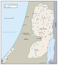
THE SETTLERS' PLAN FOR PALESTINIAN AUTONOMY, 2006
Map Details
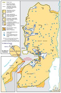
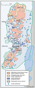
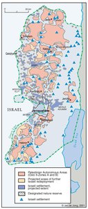
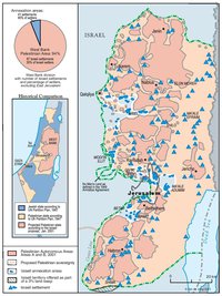
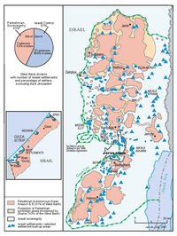
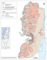
In May 2006, the Israeli settler movement put forward its own detailed political-territorial plan for Palestinian autonomy which envisaged the extension of Israeli sovereignty over large parts of the West Bank and the establishment of two independent, semi-autonomous Palestinian administrations, one in the West Bank which would be linked to Jordan and one in Gaza with links to Egypt. The "Peace in the Land" plan had been developed by a number of prominent settlers in consultation with the YESHA Council and aimed to tackle three problems identified by the settler movement: the "security problem", the "problem of ruling a foreign people" and finally the "demographic problem." According to the drafters of the plan, none of these problems could be adequately addressed through the development of a Palestinian state made up of the West Bank and Gaza because such a Palestinian state could never be viable. The main reason for this was the location of “Israeli Jerusalem” and the Ma'ale Adumim settlement bloc in the West Bank, which would compel Israel to limit the sovereignty of the Palestinian state and to exercise "control over its arms, aviation, and use of water resources, as well as its foreign relations and military." As an alternative to the supposedly non-viable two-state solution based on the pre-1967 borders, the settlers proposed a "realistic political plan" based on a number of principles. First of all, the Jewish people were said to have a historical and biblical right to Israel, a right that had allegedly been confirmed by international law. Secondly, because the Jewish people were themselves short of land, Israel could not be expected to provide the territory for a future Palestinian state on its own. Instead, a regional solution had to be sought in which both Jordan and Egypt also contributed land for the Palestinian state. Thirdly, in order to deal with the "demographic problem", Israel had to annex a part of the Palestinian population without seriously undermining the demographic makeup of the "Jewish state." Fourthly, as a solution to the "problem of ruling a foreign people", the Palestinians would have to be divided up into three categories. A first category would consist of Palestinians that "will become citizens of Israel in every aspect"; a second category of Palestinians that "will be citizens of the independent autonomous Palestinian authority […] linked to Jordan" and a third category that "will be citizens of the independent authority of Gaza and northern Sinai that will […] be linked politically to Egypt." The final two principles of the settler plan dealt with the "security problem" by reestablishing the Jordan Valley as an Israeli security zone in order to counter threats from the east as well as by extending Israeli control over other parts of the West Bank with the aim of fighting terrorism and establishing "defensible borders". The "Peace in the Land" plan envisaged the extension of Israeli sovereignty over 60% of the West Bank, including the Jordan Valley, ‘western Samaria’, ‘western Binyamin’, the Gush Etzion settlement bloc and south Mount Hebron. In order to achieve this, a new plan for settlement expansion would be developed. In addition, Israel would annex about 300,000 Palestinians living in those areas by granting them full Israeli citizenship in a staged process that could take many years. The settlers considered the consequential increase of Israel's Arab population too small to pose a threat to the "Jewish character" of Israel. For the remaining 40% of the West Bank, the settlers envisioned the establishment of a "contiguous transport system" and an independent Palestinian administration to manage their affairs in the areas of education, health, community and economy. However, Israel would not only retain the right to intervene in Palestinian affairs for security reasons, but also have full control over all security matters, all natural resources and infrastructure and even the freedom of movement in the entire West Bank. Furthermore, the "contiguous Palestinian region" would not be allowed to involve into an independent Palestinian state. Instead, on the long run, it would become part of Jordan, with its Palestinians citizens becoming "citizens of Jordan, residents of Israel, living under their own independent administration." Since the "contiguous transport system" would only apply to parts of the West Bank, but not to Gaza Strip, a safe passage route between the two Palestinian territories would not be established. Instead, Gaza would be linked with Egypt, which would have to donate some land in the Sinai to the Palestinians with the aim of alleviating the economic and humanitarian crisis in the densely populated Gaza Strip. Similar to the provision for the West Bank, Gaza would be allowed a limited form of self-government, with "the final status of the independent administration in the expanded Gaza Strip" to be "determined in negotiations between the Palestinians in Egypt" The settlers' plan also outlined an alternative solution to the Palestinian refugee question, which would involve the allocation of part of the northern Sinai to Palestinian refugees, who would then be encouraged to move to this desert area, or to Jordan or another Arab state. In effect, the Israeli settler movement proposed to create "peace in the land" by expanding the Israeli annexation of Palestinian land, denying Palestinians the right to self-determination and renouncing Israeli responsibility for the Palestinian refugees, thereby forcing the Arab states to solve the refugee question. While certain elements of the plan (such as the proposed settlement expansion) do concur with past and present Israeli policies, the plan was never endorsed by Israel, let alone any of the other parties to the conflict.
Related Maps
OTTOMAN PALESTINE, 1878
ARAB TOWNS AND JEWISH SETTLEMENTS IN PALESTINE, 1881-1914
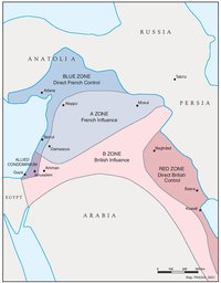
THE SYKES-PICOT AGREEMENT, 1916
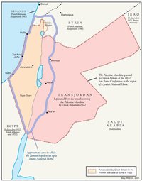
THE BEGINNING OF THE BRITISH MANDATE, 1920
PALESTINE UNDER THE BRITISH MANDATE
THE DEMOGRAPHY OF PALESTINE, 1931
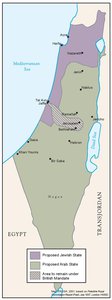
THE PEEL COMMISSION PARTITION PROPOSAL, 1937
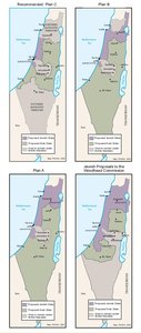
THE WOODHEAD COMMISSION PARTITION PROPOSALS, 1938
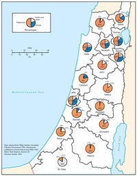
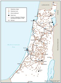
PALESTINIAN AND ZIONIST LANDOWNERSHIP BY SUB-DISTRICT, 1945
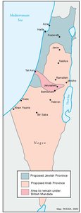
THE MORRISON-GRADY PARTITIONED TRUSTEESHIP PLAN, 1946
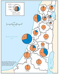
POPULATION OF PALESTINE BY SUB-DISTRICT, 1946
LAND OWNERSHIP IN PALESTINE, 1948
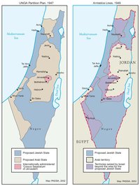
THE UNGA PARTITION PLAN, 1947 – THE 1948 WAR & THE 1949 ARMISTICE LINES
POPULATION MOVEMENTS, 1948-1951
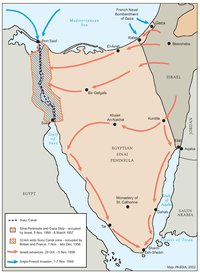
THE SUEZ WAR, 1956
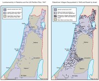
LAND OWNERSHIP IN PALESTINE AND THE UN PARTITION PLAN - PALESTINIAN DEPOPULATED AND DESTROYED VILLAGES, 1948-1949
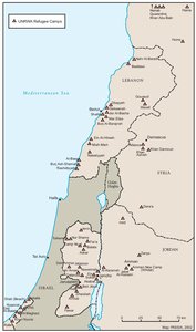
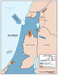
THE PALESTINIAN DIASPORA, 1958
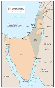
THE NEAR EAST AFTER THE JUNE 1967 WAR
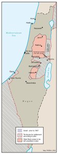
THE ALLON PLAN, JUNE 1967
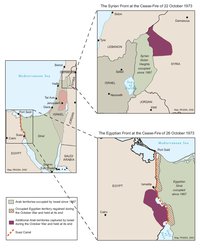
THE OCTOBER WAR, 1973
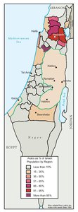
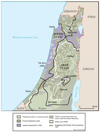
THE PALESTINIANS INSIDE ISRAEL, 1977
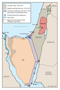
THE CAMP DAVID ACCORDS, 1978-1979
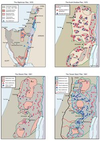
ISRAELI SETTLEMENT MASTER PLANS, 1976-1991
THE 1991 MADRID PEACE CONFERENCE & ISRAELI SETTLEMENTS
GAZA-JERICHO (OSLO I) AGREEMENT, CAIRO, 4 MAY 1994
INTERIM (OSLO II) AGREEMENT, TABA, 28 SEPTEMBER 1995
HEBRON PROTOCOL, 15 JANUARY 1997
WYE RIVER MEMORANDUM, 23 OCTOBER 1998
SHARM ESH-SHEIKH AGREEMENT, 4 SEPTEMBER 1999
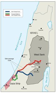
PROTOCOL CONCERNING SAFE PASSAGE BETWEEN THE WEST BANK AND THE GAZA STRIP, 5 OCTOBER 1999
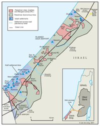
GAZA, 2000
WEST BANK AND GAZA STRIP, MARCH 2000
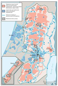
CAMP DAVID PROJECTION, JULY 2000
TABA TALKS PROJECTION, JANUARY 2001
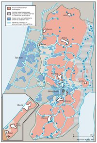
THE SHARON PROPOSAL, SPRING 2001
THE REINVASION OF THE PALESTINIAN TERRITORIES, 2001-2002
THE ROAD MAP, 2003

THE GENEVA INITIATIVE AND ACCORD, 2003
THE ISRAELI DISENGAGEMENT PLAN, 2003-2005
AGREED DOCUMENTS ON MOVEMENT AND ACCESS FROM AND TO GAZA, 2005
THE GAZA STRIP TODAY (2014)
THE WEST BANK TODAY (2014)
ADMINISTRATIVE BOUNDARIES
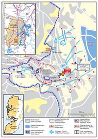
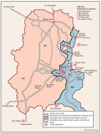
HEBRON
Area C