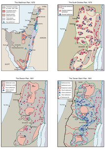
ISRAELI SETTLEMENT MASTER PLANS, 1976-1991
Map Details
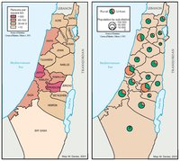
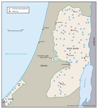
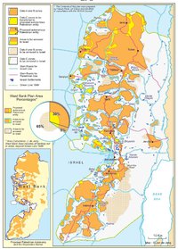
With the 1977 Likud election victory, Ariel Sharon became Chairman of the Inter-Ministerial Settlement Committee and hence responsible for drawing up guidelines for Israel’s colonization in the territories occupied in 1967. He immediately sought to merge the Likud vision of unfettered settlement with existing master plans. The Wachman, or ‘Double-Backbone Plan’, unofficially approved by Prime Minister Rabin in 1976, provided Sharon with an overall long-term vision of mass settlement. Like Allon, Wachman called for settlement primarily in sparsely populated areas. The plan aimed at maximizing Jewish demography throughout the eastern OPT, the Sinai and the Golan, while encircling - rather than settling - the major Palestinian population centers. It offered a strictly secular, pragmatic outline for securing the Jordan Rift border, the Golan Heights, the Gaza-Sinai area and the Gulf of Aqaba/Sharm Esh-Sheikh coastline. Wachman’s geostrategic vision aimed at settling 2.5 million Jews in the Golan Heights-Sharm Esh-Sheikh line, aided by long-term development, immigration and housing investment. However, the plan failed to address the national-religious imperatives of those already settling in the heart of the OPT. When Wachman refused Sharon an amended plan incorporating ‘Judea, Samaria and Gaza,’ Sharon turned to Matityahu Drobles, head of the WZO’s Land Settlement Department and a Gush Emunim loyalist, transforming existing bureaucracy to allow separate planning in the OPT. The Drobles Plan ‘nationalized’ a scheme drawn up by the messianic settler lobby Gush Emunim (Bloc of the Faithful), which Sharon had endorsed in 1977. Drobles expanded the scope of the original plan by drawing together all existing settlements and 57 new ones into blocs controlling arterial routes, ridges and water sources, breaking up Palestinian demographic continuity. Cities were encapsulated, while settlement control over west-east corridors to the Jordan Rift paralyzed Palestinian communication in a design meant to rule out forever any type of OPT autonomy. Though the Gush-Drobles plan broke any remaining taboos on the location of settlements, its radical ideological basis failed to provide the practical necessities for its fulfillment. The messianic settler movement could only offer limited human resources to the project and Israel needed mass settlement if its colonization was to be sustained. Sharon set out to transform the scheme into one affording ‘quality of life’ settlements with immediate territorial unity and overall contiguity with Israel’s coastal plain. His 1981 plan remained loyal to the Gush-Drobles vision but split the Palestinian territories into three cantons and, while leaving the way open for ideological settlement deep in the populous heart of the OPT, encouraged more substantial suburban settlement in blocs. At the time of the plan, West Bank settlers outside East Jerusalem numbered only 16,000 (with 800-900 in Gaza). By exploiting the growing demand for cheap suburban housing, Sharon aimed at settling an additional 80,000 Jews in the OPT within five years. The plan was coupled with extraordinary investment in infrastructure and services. Within two years, the settler population had nearly doubled and government expenditure on the enterprise had reached $1.5 billion. Settlements, access roads and military camps consumed 41.6% of all West Bank land and 32% of the Gaza Strip. Sharon’s plan remained the loose Likud blueprint through the 1980s, guiding expropriation, settlement and investment in the OPT. By March 1991, of the OPT’s 185,000 settlers, roughly 100,000 were living in the areas his plan targeted, the remainder in East Jerusalem. Approved by the Knesset in May 1991, the ‘Seven Stars’ plan served the dual purpose of binding the central West Bank settlements to an industrialized belt of new development towns, while eroding the demography and geography of the Green Line. The ‘star settlements’ were established on or just beyond the Green Line, targeting the ‘Little Triangle’ area, where the highest concentration of Arab-Israelis lived. With a projected population of 390,000 Jews, the plan aimed at reversing the demography of the border strip from its 1991 status - 71.5% Arab-Israeli and 28.5% Jewish - to 36% and 64% respectively by 2005.8 A new highway, Route 6, was begun to link the ‘stars’, beginning with Modi’in in the south and ending with Harish in the north, along with 14 industrial zones and numerous new towns, creating a north-south strip separating Arab-Israeli villages from one another, their land and the OPT. Mass confiscations were made to facilitate the plan, which brought high-level infrastructure closer to the suburban OPT settlements and shattered the socio-economic fiber of Arab-Israeli communities in the area. The ‘Seven Star’ plan reflected the extent to which Israel’s entire national development program, with settlement at its heart, had been put to the service of destroying forever any possibility of Palestinian territorial or demographic contiguity. Though all master plans were based on long-term projections and underwent changes in implementation, their geo-political impact was immediate and long-term. Master plans were aimed not merely at delimiting areas of Jewish settlement, but at maximizing the confinement of Palestinian development, severing communication lines and robbing the indigenous population of its natural resources.
Related Maps
OTTOMAN PALESTINE, 1878
ARAB TOWNS AND JEWISH SETTLEMENTS IN PALESTINE, 1881-1914
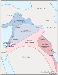
THE SYKES-PICOT AGREEMENT, 1916
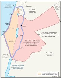
THE BEGINNING OF THE BRITISH MANDATE, 1920
PALESTINE UNDER THE BRITISH MANDATE
THE DEMOGRAPHY OF PALESTINE, 1931
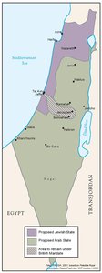
THE PEEL COMMISSION PARTITION PROPOSAL, 1937
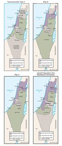
THE WOODHEAD COMMISSION PARTITION PROPOSALS, 1938
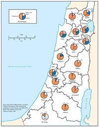
PALESTINIAN AND ZIONIST LANDOWNERSHIP BY SUB-DISTRICT, 1945
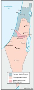
THE MORRISON-GRADY PARTITIONED TRUSTEESHIP PLAN, 1946
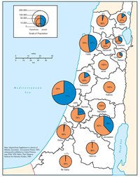
POPULATION OF PALESTINE BY SUB-DISTRICT, 1946
LAND OWNERSHIP IN PALESTINE, 1948
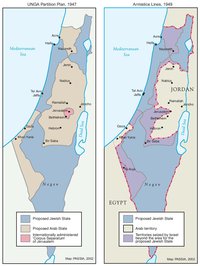
THE UNGA PARTITION PLAN, 1947 – THE 1948 WAR & THE 1949 ARMISTICE LINES
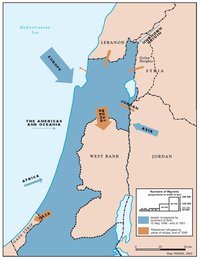
POPULATION MOVEMENTS, 1948-1951
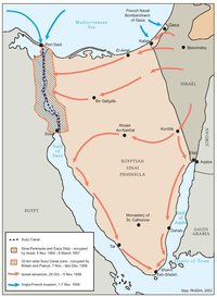
THE SUEZ WAR, 1956
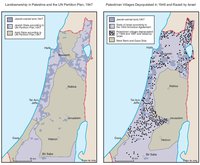
LAND OWNERSHIP IN PALESTINE AND THE UN PARTITION PLAN - PALESTINIAN DEPOPULATED AND DESTROYED VILLAGES, 1948-1949
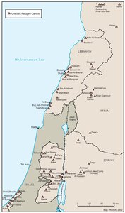
THE PALESTINIAN DIASPORA, 1958
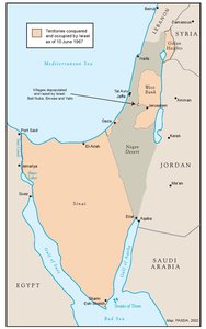
THE NEAR EAST AFTER THE JUNE 1967 WAR
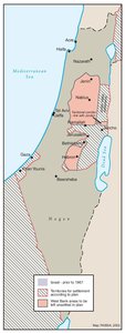
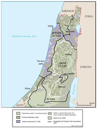
THE ALLON PLAN, JUNE 1967
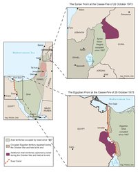
THE OCTOBER WAR, 1973

THE PALESTINIANS INSIDE ISRAEL, 1977
THE CAMP DAVID ACCORDS, 1978-1979
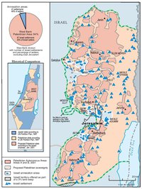
THE 1991 MADRID PEACE CONFERENCE & ISRAELI SETTLEMENTS
GAZA-JERICHO (OSLO I) AGREEMENT, CAIRO, 4 MAY 1994
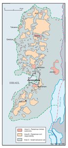
INTERIM (OSLO II) AGREEMENT, TABA, 28 SEPTEMBER 1995
HEBRON PROTOCOL, 15 JANUARY 1997
WYE RIVER MEMORANDUM, 23 OCTOBER 1998
SHARM ESH-SHEIKH AGREEMENT, 4 SEPTEMBER 1999
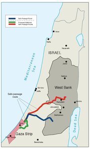
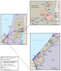
PROTOCOL CONCERNING SAFE PASSAGE BETWEEN THE WEST BANK AND THE GAZA STRIP, 5 OCTOBER 1999
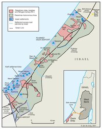
GAZA, 2000
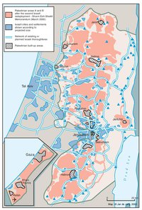
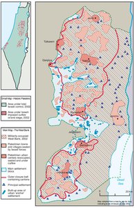
WEST BANK AND GAZA STRIP, MARCH 2000
CAMP DAVID PROJECTION, JULY 2000
TABA TALKS PROJECTION, JANUARY 2001
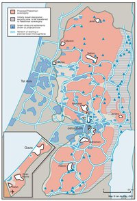
THE SHARON PROPOSAL, SPRING 2001
THE REINVASION OF THE PALESTINIAN TERRITORIES, 2001-2002
THE ROAD MAP, 2003
THE GENEVA INITIATIVE AND ACCORD, 2003
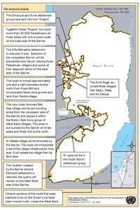
THE ISRAELI DISENGAGEMENT PLAN, 2003-2005
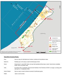
AGREED DOCUMENTS ON MOVEMENT AND ACCESS FROM AND TO GAZA, 2005

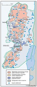
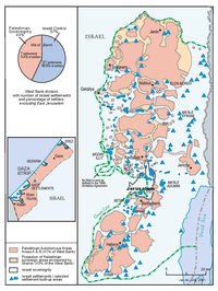
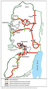
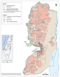
THE SETTLERS' PLAN FOR PALESTINIAN AUTONOMY, 2006
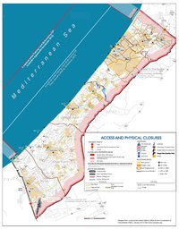
THE GAZA STRIP TODAY (2014)
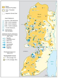
THE WEST BANK TODAY (2014)
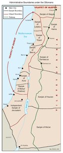
ADMINISTRATIVE BOUNDARIES

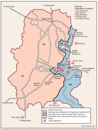
HEBRON
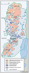
Area C