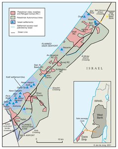
GAZA, 2000
Map Details
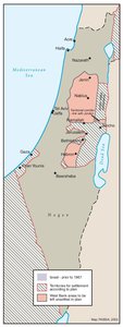
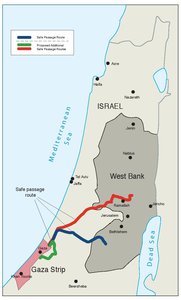
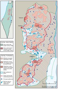
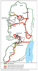
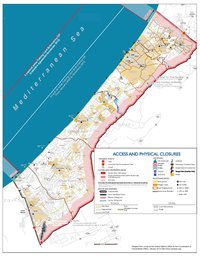
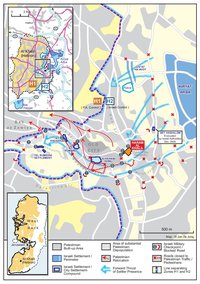
Israel’s chief legal adviser, Joel Singer, remarked during the negotiations that led to the 1994 Gaza-Jericho (Oslo I) Accord that, “the nature of the Palestinian formation will be neither independent nor sovereign - it will be vastly subordinate to the authority of the military government.” The Gaza Strip, six years after the Oslo I redeployments, stood as testimony to this fact. The PA controlled 210 km2 (58%) of the Strip’s 365 km2. The remaining Israeli-controlled area was made up of some 19 settlements, three lateral settler access roads (and their perimeter areas), the southern Egyptian border region, the northern Erez checkpoint area, and a security perimeter alongside the eastern border’s electric fence. In addition, Gaza’s coastal (Mediterranean) border was limited by two security cordons, stretching 32 km out to sea at both the north and the south of the Strip, confining Palestinian fishing vessels to a ‘Zone L’ between the two. The large Gush Katif settlement cluster in the south, with the tiny, isolated sites of Kfar Darom and Netzarim in the central area and the Elei Sinai-Dugit sites in the north, remained heavily protected by the Israeli army. Their access roads, under military guard and exclusive Israeli control, left Palestinian movement in the 45 km Strip dependent on Israeli acquiescence. The erection of military camps, fortifications and checkpoints on these lateral roads following the 1994 redeployments, coupled with the closure of the Gaza Strip - in place ever since 1994 - led to the phenomenon of the ‘internal Gaza closure.' Not only was Gaza cut off from the West Bank and Israel, but at its discretion, Israel severed the connections between southern, central and northern Gaza for days on end. Thousands of Gaza Palestinians, including numerous university students, remained stranded for months if not years in the West Bank, unable to move legally there and yet prevented from returning to their homes. The closure of Gaza had a devastating effect on the economy, rendered highly dependent on day laborers in Israel and ‘exports’ to or via Israel by the decades of occupation. Between 1992 and 1996 the per-capita GNP dropped by 37% as a result of the closure. By mid-1996 unemployment affected 66% of the workforce. In 1998, the National Commission for Poverty Eradication listed 51% of southern Gazans, 39.5% of central Gazans and 31% of those in the north as living in poverty (on under $2 per day). Two thirds of Gaza’s poor were in a state of “absolute poverty,” i.e., unable to meet basic nutritional needs. In 2000, UNRWA put the total Gaza Strip population at nearly 1,100,000, of which 78% were RRs, comprising the largest refugee population outside Jordan. Some 9% of this relied on “Special Hardship” assistance. Over half of Gaza’s 844,622 RRs remained in one of the Strip’s eight camps. In the largest of these, Jabalia, the population density was equivalent to 83,375 persons per km2. Meanwhile, Gaza’s mere 6,900 settlers provided the pretext for Israel’s ongoing control of the Strip’s arterial routes, subterranean water and scant land resources. Through the 1990s, the average Gaza settler had 699 times as much land as the average Palestinian refugee in Gaza. The settlements’ control over aquifers had long reduced the quality and quantity of potable Gaza water, but settler consumption remained 16-30 times that of the Palestinian per capita rate (see Map 66). Palestinians in Gaza were obliged to pay at least four times the rate granted the settlers by Israel’s water company, which retained its control over the flow. Following 1994, no further redeployments in Gaza were addressed in negotiations. Only in November 1998 did Israel partially fulfill its 1994 obligations and allow the Gaza airport to open - under Israeli security control. A year later, work was allowed to begin on the seaport. Gaza’s extended isolation from the West Bank was a violation of Israel’s Oslo I obligation to provide “safe passage” routes. One such route – the southern safe passage leading from Erez checkpoint to Tarqumiyya near Hebron - was opened on 18 October 1999, though its use was limited to a quota of Palestinians granted approval by Israeli security officials. Likewise, Israel retained exclusive control of the Egyptian border crossing points south of Rafah. The crossing points along the eastern Gaza Strip border were retained for settler access only, along with commercial goods, the transit of which was conducted by Israeli security and taxation agencies, leaving individual merchants and the wider Gaza economy at their ‘mercy’. The degree of control Israel retained over the fractured and isolated Gaza Strip in 2000 underscored its major Oslo achievement: while shedding the expensive, politically awkward and potentially dangerous burden of administering its inhabitants, Israel had ensured itself near absolute authority over their economy, movement, land and resources. Gaza, more than anywhere else, illustrated the role of the settlements in perpetuating this form of oppression.
Related Maps
OTTOMAN PALESTINE, 1878
ARAB TOWNS AND JEWISH SETTLEMENTS IN PALESTINE, 1881-1914
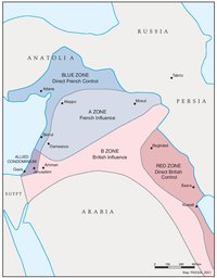
THE SYKES-PICOT AGREEMENT, 1916
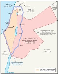
THE BEGINNING OF THE BRITISH MANDATE, 1920
PALESTINE UNDER THE BRITISH MANDATE
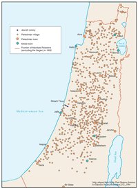
THE DEMOGRAPHY OF PALESTINE, 1931
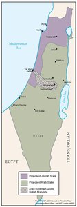
THE PEEL COMMISSION PARTITION PROPOSAL, 1937
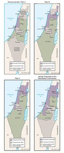
THE WOODHEAD COMMISSION PARTITION PROPOSALS, 1938
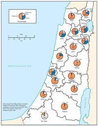
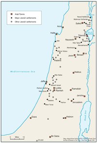
PALESTINIAN AND ZIONIST LANDOWNERSHIP BY SUB-DISTRICT, 1945
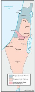
THE MORRISON-GRADY PARTITIONED TRUSTEESHIP PLAN, 1946
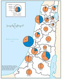
POPULATION OF PALESTINE BY SUB-DISTRICT, 1946
LAND OWNERSHIP IN PALESTINE, 1948
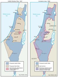
THE UNGA PARTITION PLAN, 1947 – THE 1948 WAR & THE 1949 ARMISTICE LINES
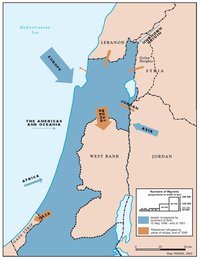
POPULATION MOVEMENTS, 1948-1951
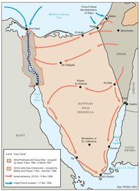
THE SUEZ WAR, 1956
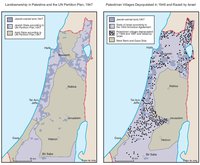
LAND OWNERSHIP IN PALESTINE AND THE UN PARTITION PLAN - PALESTINIAN DEPOPULATED AND DESTROYED VILLAGES, 1948-1949
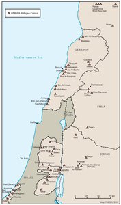
THE PALESTINIAN DIASPORA, 1958
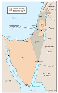
THE NEAR EAST AFTER THE JUNE 1967 WAR
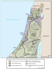
THE ALLON PLAN, JUNE 1967
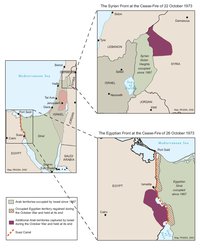
THE OCTOBER WAR, 1973
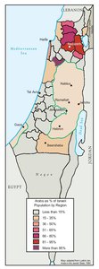
THE PALESTINIANS INSIDE ISRAEL, 1977
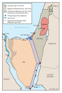
THE CAMP DAVID ACCORDS, 1978-1979
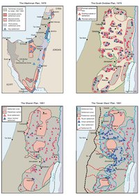
ISRAELI SETTLEMENT MASTER PLANS, 1976-1991
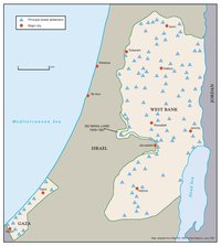
THE 1991 MADRID PEACE CONFERENCE & ISRAELI SETTLEMENTS
GAZA-JERICHO (OSLO I) AGREEMENT, CAIRO, 4 MAY 1994
INTERIM (OSLO II) AGREEMENT, TABA, 28 SEPTEMBER 1995
HEBRON PROTOCOL, 15 JANUARY 1997
WYE RIVER MEMORANDUM, 23 OCTOBER 1998
SHARM ESH-SHEIKH AGREEMENT, 4 SEPTEMBER 1999
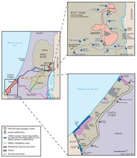
PROTOCOL CONCERNING SAFE PASSAGE BETWEEN THE WEST BANK AND THE GAZA STRIP, 5 OCTOBER 1999
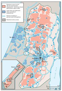
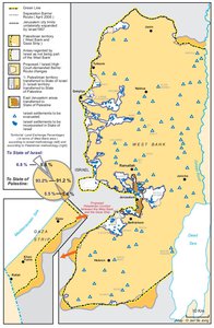
WEST BANK AND GAZA STRIP, MARCH 2000
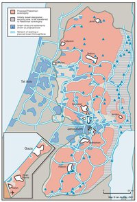
CAMP DAVID PROJECTION, JULY 2000
TABA TALKS PROJECTION, JANUARY 2001
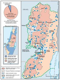
THE SHARON PROPOSAL, SPRING 2001
THE REINVASION OF THE PALESTINIAN TERRITORIES, 2001-2002
THE ROAD MAP, 2003
THE GENEVA INITIATIVE AND ACCORD, 2003
THE ISRAELI DISENGAGEMENT PLAN, 2003-2005
AGREED DOCUMENTS ON MOVEMENT AND ACCESS FROM AND TO GAZA, 2005

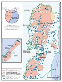
THE SETTLERS' PLAN FOR PALESTINIAN AUTONOMY, 2006
THE GAZA STRIP TODAY (2014)
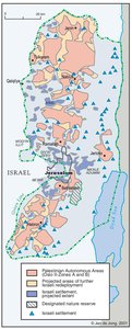
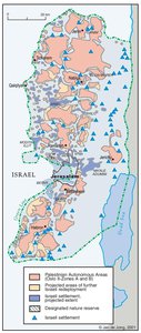
THE WEST BANK TODAY (2014)
ADMINISTRATIVE BOUNDARIES
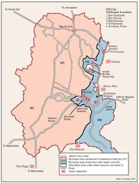
HEBRON
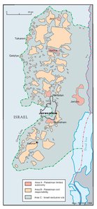
Area C