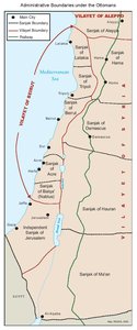
OTTOMAN PALESTINE, 1878
Map Details
The population of Ottoman Palestine in 1878, totaling 440,850, was made up of several ethnic groups and
members of various denominations of the three monotheistic faiths. Each of these had maintained a
presence of varying size in the area for well over ten centuries.
Some 386,320 Muslim Palestinian Arabs represented the overwhelming majority (88%) in a land, which had
been under uninterrupted Muslim rule since 1187. This population included both Sunni (the vast majority)
and Shi’ite communities, as well as members of the Druze sect. The overwhelming majority of the population
was rural, with agriculture as the principal source of income and the center of traditional life.
There were 40,588 (9%) Christian Palestinian Arabs, belonging to the Greek Orthodox (63%) and Roman
Catholic (24%), as well as the Armenian, Greek Catholic and Protestant denominations. Communities -
many of which had roots going back to the dawn of Christianity - were generally, though not exclusively,
urban, residing in Nazareth, Jerusalem, Bethlehem, Haifa and Jaffa in significant numbers.
Some 13,942 Jews (3%) lived in predominantly urban communities, with centers in Safed and Jerusalem as
well as Hebron and Tiberias. Their economy was almost entirely dependent on remittances from Jewish
communities abroad.
In addition to these three principle sectors, there were approximately 200 members of the ancient
Samaritan community living on the edge of Nablus and a small number of Gypsies, who were a mixture of
Christian and Muslim converts.
The existing Jewish population, prior to the advent of political Zionism, consisted primarily of Orthodox Jews
without a nationalist agenda. Nonetheless, by 1878 pre-Zionist trends were already evincing a changed
attitude towards the land of Palestine. Various European financiers, notably Moses Montefiore of London,
were quietly negotiating with Ottoman officials in an effort to purchase land and establish settlements.
Additionally, members of the established community sought a more ‘production’ oriented lifestyle, removed
from their dependency on the community leaders’ distribution of foreign remittances. Thus, in 1878, led by
Joel Salomon (who had, in 1869, established the first Jewish settlement outside Jerusalem’s Old City walls),
26 Jerusalem families purchased a tract of land some 9 km from Jaffa, on the banks of Al-Aujah River (now
the Yarkon).
Naming the site “Petah Tikva” (Portal of Hope) the colonists set about cultivating the plot, which was part of
the grazing land of the Arab village of Al-Abbasiyya, causing friction not due to their presence on the land so
much as their lack of familiarity with established rural ways - particularly with regard to boundaries and the
custom of loose-grazing. However, the initial colonists at “Petah Tikva” were to fail and return to Jerusalem
in their second year, defeated by malaria, their lack of agricultural knowledge and, eventually, a flood. A
second, more successful settlement was established near the site in 1882 and is now a large town.
Related Maps
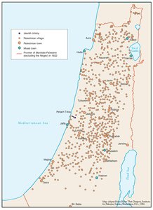
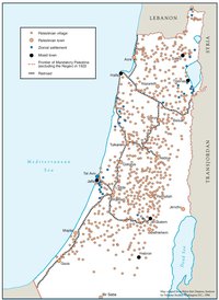
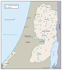
ARAB TOWNS AND JEWISH SETTLEMENTS IN PALESTINE, 1881-1914
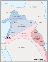
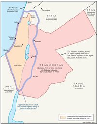
THE SYKES-PICOT AGREEMENT, 1916
THE BEGINNING OF THE BRITISH MANDATE, 1920
PALESTINE UNDER THE BRITISH MANDATE
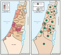
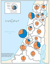
THE DEMOGRAPHY OF PALESTINE, 1931
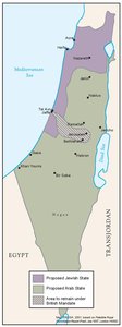
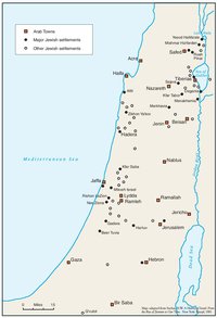
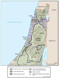
THE PEEL COMMISSION PARTITION PROPOSAL, 1937
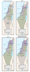
THE WOODHEAD COMMISSION PARTITION PROPOSALS, 1938
PALESTINIAN AND ZIONIST LANDOWNERSHIP BY SUB-DISTRICT, 1945
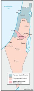
THE MORRISON-GRADY PARTITIONED TRUSTEESHIP PLAN, 1946
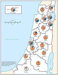
POPULATION OF PALESTINE BY SUB-DISTRICT, 1946
LAND OWNERSHIP IN PALESTINE, 1948
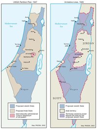
THE UNGA PARTITION PLAN, 1947 – THE 1948 WAR & THE 1949 ARMISTICE LINES
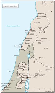
POPULATION MOVEMENTS, 1948-1951
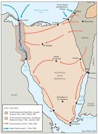
THE SUEZ WAR, 1956
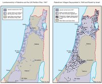
LAND OWNERSHIP IN PALESTINE AND THE UN PARTITION PLAN - PALESTINIAN DEPOPULATED AND DESTROYED VILLAGES, 1948-1949
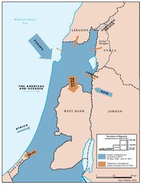
THE PALESTINIAN DIASPORA, 1958
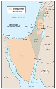
THE NEAR EAST AFTER THE JUNE 1967 WAR
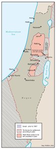
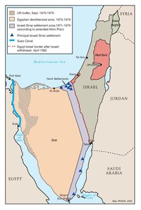
THE ALLON PLAN, JUNE 1967
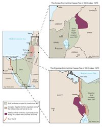
THE OCTOBER WAR, 1973
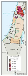
THE PALESTINIANS INSIDE ISRAEL, 1977
THE CAMP DAVID ACCORDS, 1978-1979
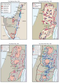
ISRAELI SETTLEMENT MASTER PLANS, 1976-1991
THE 1991 MADRID PEACE CONFERENCE & ISRAELI SETTLEMENTS
GAZA-JERICHO (OSLO I) AGREEMENT, CAIRO, 4 MAY 1994
INTERIM (OSLO II) AGREEMENT, TABA, 28 SEPTEMBER 1995
HEBRON PROTOCOL, 15 JANUARY 1997
WYE RIVER MEMORANDUM, 23 OCTOBER 1998
SHARM ESH-SHEIKH AGREEMENT, 4 SEPTEMBER 1999
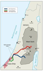
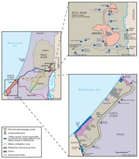
PROTOCOL CONCERNING SAFE PASSAGE BETWEEN THE WEST BANK AND THE GAZA STRIP, 5 OCTOBER 1999
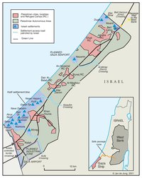
GAZA, 2000
WEST BANK AND GAZA STRIP, MARCH 2000
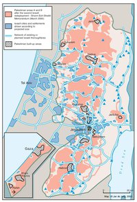
CAMP DAVID PROJECTION, JULY 2000
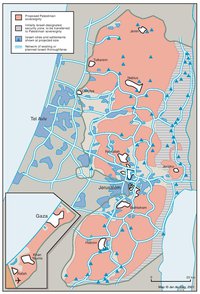
TABA TALKS PROJECTION, JANUARY 2001
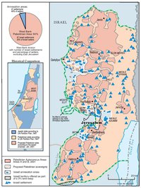
THE SHARON PROPOSAL, SPRING 2001
THE REINVASION OF THE PALESTINIAN TERRITORIES, 2001-2002
THE ROAD MAP, 2003
THE GENEVA INITIATIVE AND ACCORD, 2003
THE ISRAELI DISENGAGEMENT PLAN, 2003-2005
AGREED DOCUMENTS ON MOVEMENT AND ACCESS FROM AND TO GAZA, 2005

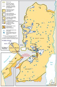
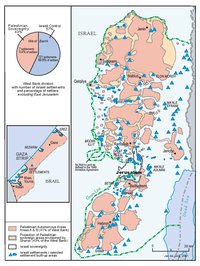
THE SETTLERS' PLAN FOR PALESTINIAN AUTONOMY, 2006
THE GAZA STRIP TODAY (2014)
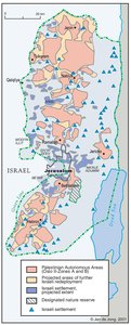
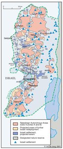
THE WEST BANK TODAY (2014)
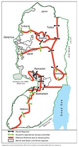
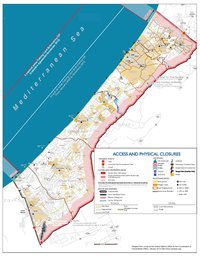
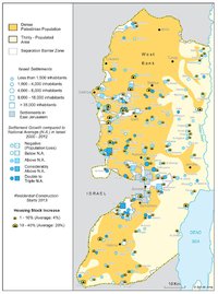
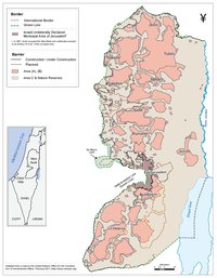
ADMINISTRATIVE BOUNDARIES
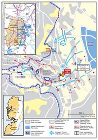
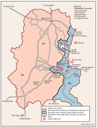
HEBRON
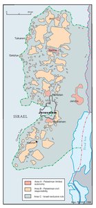
Area C