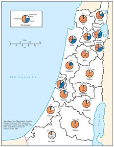
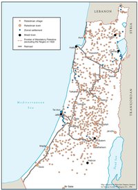
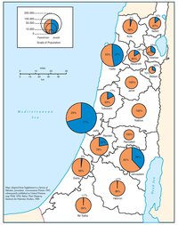
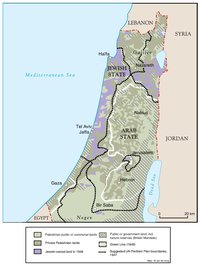
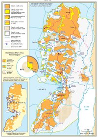
PALESTINIAN AND ZIONIST LANDOWNERSHIP BY SUB-DISTRICT, 1945
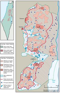
Map Details
Land acquisition and immigration were the two overarching aims of the Zionist movement from its inception
and they defined the nature of Mandate Palestine as well as Jewish-Arab relations more than any other
factor.
When the British came to power in 1918, 2% of Palestine’s 6,500,000 acres were owned by Jews. By 1944,
the Jewish population had risen from 8% of the total to 31% and the WZO’s actual land holdings had
tripled. The acquisition of land was entrusted to the JA in 1929 and was carried out systematically in
accordance with a goal of securing the maximum contiguous area of exclusively Jewish agricultural land
possible. Early acquisitions in the lower Galilee area, made through the aggressive methods of Zionist land
dealer Joshua Chankin, were expanded upon throughout the 1920s and 1930s, creating the largest
cultivable area of Jewish ownership in Palestine: the so-called Jezreel Valley. Again, it was the tenant
farmers and small holders who fell victim, while the landowners frequently resided abroad and stood to
make enormous sums in a period of economic decline in agriculture and yet phenomenal rises in land
value. Sustaining and expanding the Zionist agricultural settlements was a WZO imperative; thus, the JA
and JNF were obliged to finance the farms, whose actual production value was negligible and unviable.
Between 1920 and 1945, the Mandate Land Registry recorded 584,191 transactions as Zionist holdings
rose to 1.7 million dunums. A British “Employment Committee” established in 1944 noted that at least
47,000 Arabs had left the agricultural workforce in the preceding five-year period and by 1946, the Mandate
reported that “the Jews [hold] over 15% of the cultivable area of Palestine.” Already by 1931, the extent of
the dispossession caused by the Zionists, particularly in the northern agricultural belt, had forced the British
to establish a “Development Commission” charged with registering “landless Arabs” and preparing a
“scheme for their resettlement.” The unpopular resettlement project was soon abandoned though, and
even when British attempts were made in the early 1940s to limit the pace and scale of the Zionists’ impact
- these were next to futile. Repeatedly, land transfer regulations were circumvented or revoked. One
commentator has characterized the role of the British in the period as that of “an umpire trying in vain to
implant new regulations into the land transfer game that, as time wore on, became increasingly complex,
devious and uncontrollable.”
The Palestinians remained, in spite of the enormous pressures and massive losses, dominant in the
agricultural sector throughout Palestine and the overwhelming majority of both large and small owners
managed to hold onto their land. As the map indicates, in none of the 16 sub-districts of the Mandate did the
Zionists own a majority of the land and in half of them Jewish ownership remained negligible (5% or less).
Nonetheless, the speed and apparent ease with which the Zionists had gained a strong territorial foothold in
the agricultural heart of rural Palestine stood as testimony to Britain’s failure to fulfill many of the terms of its
Mandate.
The Mandate document had supposedly committed Britain to ensure that “[n]o discrimination of any kind
shall be made between the inhabitants of Palestine on the ground of race, religion or language.” In 1944,
the British Labour Party adopted a resolution on Palestine in favor of “the transfer of the population,”
deciding it best that “the Arabs be encouraged to move out as the Jews move in.” The following July,
Clement Attlee led the Labour party to victory in the British general election.
Related Maps
OTTOMAN PALESTINE, 1878
ARAB TOWNS AND JEWISH SETTLEMENTS IN PALESTINE, 1881-1914
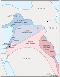
THE SYKES-PICOT AGREEMENT, 1916
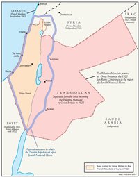
THE BEGINNING OF THE BRITISH MANDATE, 1920
PALESTINE UNDER THE BRITISH MANDATE
THE DEMOGRAPHY OF PALESTINE, 1931
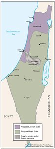
THE PEEL COMMISSION PARTITION PROPOSAL, 1937
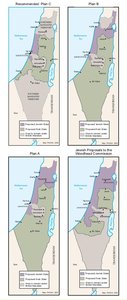
THE WOODHEAD COMMISSION PARTITION PROPOSALS, 1938
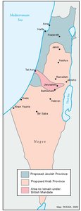
THE MORRISON-GRADY PARTITIONED TRUSTEESHIP PLAN, 1946
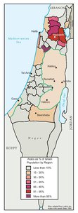
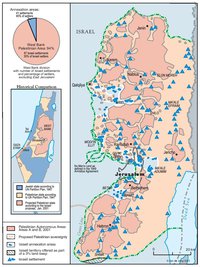
POPULATION OF PALESTINE BY SUB-DISTRICT, 1946
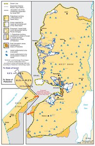
LAND OWNERSHIP IN PALESTINE, 1948
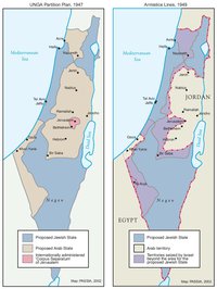
THE UNGA PARTITION PLAN, 1947 – THE 1948 WAR & THE 1949 ARMISTICE LINES
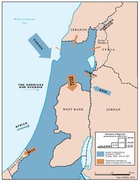
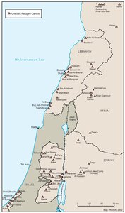
POPULATION MOVEMENTS, 1948-1951
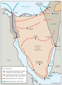
THE SUEZ WAR, 1956
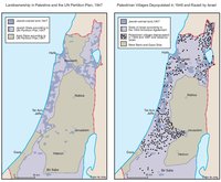
LAND OWNERSHIP IN PALESTINE AND THE UN PARTITION PLAN - PALESTINIAN DEPOPULATED AND DESTROYED VILLAGES, 1948-1949
THE PALESTINIAN DIASPORA, 1958
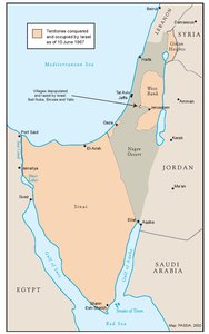
THE NEAR EAST AFTER THE JUNE 1967 WAR
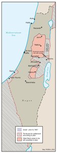
THE ALLON PLAN, JUNE 1967
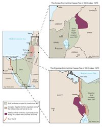
THE OCTOBER WAR, 1973
THE PALESTINIANS INSIDE ISRAEL, 1977
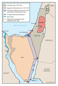
THE CAMP DAVID ACCORDS, 1978-1979
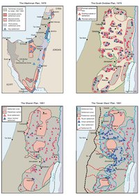
ISRAELI SETTLEMENT MASTER PLANS, 1976-1991
THE 1991 MADRID PEACE CONFERENCE & ISRAELI SETTLEMENTS
GAZA-JERICHO (OSLO I) AGREEMENT, CAIRO, 4 MAY 1994
INTERIM (OSLO II) AGREEMENT, TABA, 28 SEPTEMBER 1995
HEBRON PROTOCOL, 15 JANUARY 1997
WYE RIVER MEMORANDUM, 23 OCTOBER 1998
SHARM ESH-SHEIKH AGREEMENT, 4 SEPTEMBER 1999
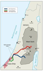
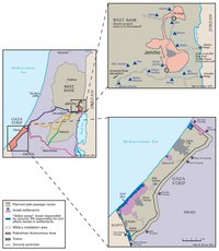
PROTOCOL CONCERNING SAFE PASSAGE BETWEEN THE WEST BANK AND THE GAZA STRIP, 5 OCTOBER 1999
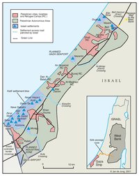
GAZA, 2000
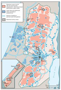
WEST BANK AND GAZA STRIP, MARCH 2000
CAMP DAVID PROJECTION, JULY 2000
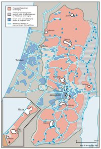
TABA TALKS PROJECTION, JANUARY 2001
THE SHARON PROPOSAL, SPRING 2001
THE REINVASION OF THE PALESTINIAN TERRITORIES, 2001-2002
THE ROAD MAP, 2003
THE GENEVA INITIATIVE AND ACCORD, 2003
THE ISRAELI DISENGAGEMENT PLAN, 2003-2005
AGREED DOCUMENTS ON MOVEMENT AND ACCESS FROM AND TO GAZA, 2005

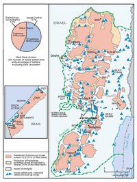
THE SETTLERS' PLAN FOR PALESTINIAN AUTONOMY, 2006
THE GAZA STRIP TODAY (2014)
THE WEST BANK TODAY (2014)
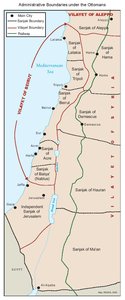
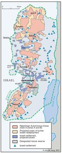
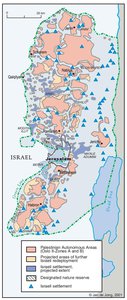
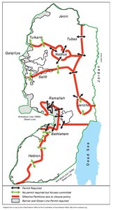
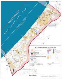
ADMINISTRATIVE BOUNDARIES
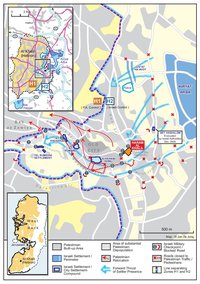
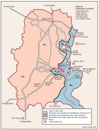
HEBRON
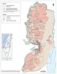
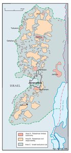
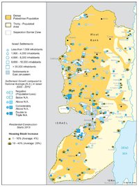
Area C