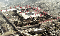
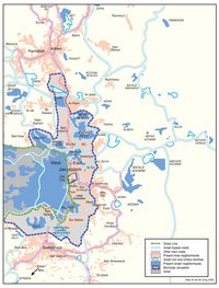
ISRAELI SETTLEMENTS AND PALESTINIAN NEIGHBORHOODS IN EAST JERUSALEM, 2000
Map Details
Calculating the Palestinian population in East Jerusalem with any exactitude poses a number of difficulties.
The root of this problem is the discriminatory policies enforced by the Israeli Minister of Interior since 1967.
After conquering East Jerusalem, Israel conducted a census wherein roughly 66,000 Palestinians were
registered as residents of the city. Those who had vacated the city during the 1967 War or were abroad at
the time – altogether over 25,000 Jerusalemites – were arbitrarily denied registration. Adapting its ‘Law of
Entry Into Israel’ of 1952, Israel then limited the right to live in the city to those officially registered in 1967
and their descendents, issuing blue Jerusalem ID cards to these individuals, classifying them as ‘permanent
residents’ (i.e., foreigners afforded residency). Palestinians who live outside the city for longer than seven
years, regardless of the purpose, as well as those who fail to prove that their “center of life” is within the
municipal boundaries, stand to have their residency rights revoked. Those unregistered Palestinians who
marry registered East Jerusalemites or choose to return to the East Jerusalem area after the revocation of
their residency, must petition the Minister of Interior for “family reunification.” The Ministry is not obliged to
offer any explanation of its decisions in these instances. Between 1967-2001, Israel revoked the residency
rights of 6,444 Palestinian Jerusalemites.
As a result of such draconian policies, Palestinians are generally wary of approaching the Israeli Minister of
Interior in total transparency, rendering Israel population data for the Palestinians in the city subject to error.
In 2000, official Israeli projections put the figure at 208,700 – being 31.7% of the total. The PCBS – which
has been denied access to conduct its own survey in the city – estimated a far higher figure of 238,561,
which includes an unknown number of Palestinians holding Jerusalem ID cards but residing in the West
Bank. The severity of Israel’s limitations on Palestinian development and construction meant,
by 2000, average Palestinian housing density was at least double that of the Jewish population in the city,
and 30% of Palestinians were living in density equivalent to three people per room.
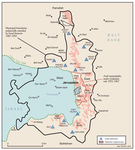
Meanwhile, since 1967, Israel’s East Jerusalem settlements, at the fore of national development planning,
have grown into vast, heavily subsidized, urban townships, ringing the city and sprawling over the expropriated
lands of its Palestinian residents. From 1967-2000, 75-80% of all Jerusalem’s Jewish population
growth occurred in this 10-point ‘inner ring’ of urban settlements. The ‘inner ring’ is itself the link between
West Jerusalem and the ‘outer ring’ of settlements. It serves to bind the West territorially and
demographically to the occupied East of the city. The 10 main sites underpinning the program – as shown
in the map – are themselves made up of connected individual settlement ‘neighborhoods’. These large
centers, described by Israel’s city planners as the Jerusalem’s “new ramparts,” are in addition to the
smaller-scale settlements, which proliferate in and around the Old City.
The ‘inner ring’ sites were established in stages. Between 1968-1973, Israel used a 1943 Public Purposes
and Land Ordinance to expropriate most of the necessary land for the entire program and established the
first sites: French Hill/Ramat Eshkol (1968); Atarot (1970); Gilo (1971); Neve Ya’acov (1972); East Talpiot
(1973); and Ramot (1973). In 1985, Israel added Pisgat Ze’ev, on 4,400 dunums of Beit Hanina and Hizma
village land. Then, in 1991, Givat HaMatos and Har Homa were founded (though work on the latter was
delayed until 1997), followed in 1994 by Rekhes Shu’fat. In total, over 23,300 dunums of East Jerusalem
land was expropriated for the express purpose of constructing these 10 anchor sites of the ‘inner ring’. The
land loss impinged hugely on the prospects of 12 large Palestinian neighborhoods and three outlying West
Bank villages, effectively ruling out their own development entirely.
By investing heavily in overpass and bypass roads to link these sites, Israel has afforded the settlements
uninterrupted communication lines with each other and West Jerusalem. Passage from Har Homa in the
south through to Neve Ya’acov in the northeast can be made in a matter of minutes and without any point of
contact with the non-Jewish residents of the city or their underdeveloped infrastructure. In contrast,
Palestinian movement within and through the city is hindered greatly by the absence of appropriate routes
and the harassment inherent in the two-tier system of administrative and security control under which the
settlements oblige them to live. In 2001, the population of the ‘inner ring’ settlements reached the 200,000
mark, meaning half of all Israeli OPT settlers were residing in illegally annexed and expanded Arab East
Jerusalem.
Related Maps
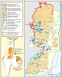
ISRAEL'S SEPARATION BARRIER, 2002
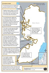
REVISED ROUTE OF THE ISRAELI SEPARATION BARRIER, 2006
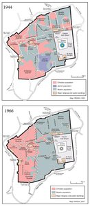
THE OLD CITY, 1944 & 1966
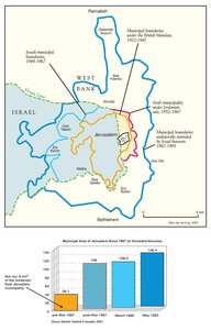
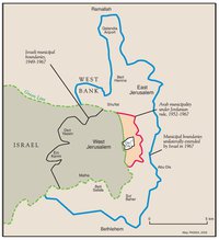
MUNICIPAL BOUNDARIES OF JERUSALEM, 1947-2000
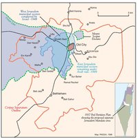
JERUSALEM AND THE CORPUS SEPARATUM PROPOSED IN 1947
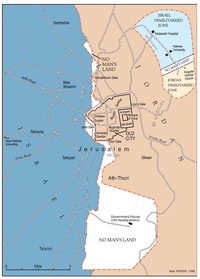
PARTITIONED JERUSALEM, 1948-1967
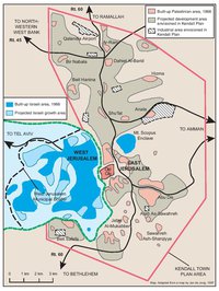
THE KENDALL TOWN SCHEME, 1966
JERUSALEM AFTER THE 1967 WAR
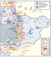
ISRAELI SETTLEMENTS AND PALESTINIAN NEIGHBORHOODS IN METROPOLITAN JERUSALEM, 2000
ARAB EAST JERUSALEM WITHIN ‘GREATER’ JERUSALEM, 2000
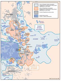
PROJECTION OF THE ISRAELI PROPOSAL FOR JERUSALEM’S FINAL STATUS AT CAMP DAVID, JULY 2000
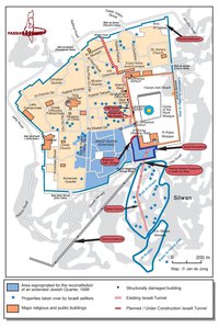
SETTLEMENT ACTIVITY IN THE OLD CITY
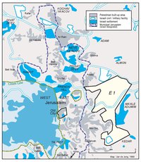
THE E-1 DEVELOPMENT PLAN
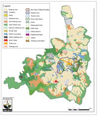
THE JERUSALEM MASTER PLAN
JERUSALEM TODAY (2014)