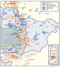
REVISED ROUTE OF THE ISRAELI SEPARATION BARRIER, 2006
Map Details
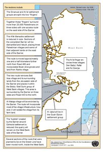
After various Israeli government decisions to revise the route of the separation barrier in the West Bank the Israeli cabinet approved a more or less final route in April 2006. In its decision, the Israeli government followed the Israeli High Court of Justice which, while rejecting the claim by Palestinians and Israeli human rights organizations that the separation barrier was built for political rather than security reasons, had ruled on several occasions that the balance between security and humanitarian considerations was disproportionate, demanding the route be altered in order to cause less harm to the Palestinian population. In its rulings, Israel’s High Court had ignored the issue of the illegality of the Israeli settlements, which primarily dictated the convoluted route of the barrier. Thus, while neglecting international condemnation of the barrier as a violation of international law, the High Court had preferred to focus on tests of proportionality, leading it to demand changes in the route in a few places without preventing construction of the barrier deep inside the West Bank and the severe damage, expropriation and restriction of movement inflicted on the Palestinian population as a result thereof. Based on the official map of the new route the Israeli "security fence" would be – upon completion – over 700 km long, more than twice the length of the 1949 Armistice Line (the Green Line), which is only 315 km long. At least 80% of the separation barrier would thus not follow the Green Line, but instead be built inside the West Bank, i.e., on Palestinian land. Furthermore, the construction of the barrier along this route, combined with planned Israeli settlement expansion, would lead to the de facto annexation of about 45.5% of the West Bank by Israel. This includes some 9.0% of the West Bank falling outside the separation barrier, with settlements inside the barrier accounting for an additional 8.0% and the Jordan Valley, which would be almost exclusively controlled by Israeli settlements, making up another 28.5% of the West Bank. If the barrier were to be completed according to the 2006 route, about 60,500 Palestinians in 42 West Bank villages and towns would end up living "in areas between the barrier and the Green Line or in closed areas" while an additional 124,300 Palestinians in 28 villages would be "located on the east side, but surrounded by the barrier on three sides and controlled on the fourth with an associated physical closure." In addition, the barrier would "separate or isolate over 230,000 Palestinian Jerusalemites from the rest of the West Bank" as well as "further separate over 2 million Palestinians living on the 'eastern' side of the Wall from East Jerusalem." Furthermore, the construction of the barrier along the designated route would have grave humanitarian consequences for Palestinians in and outside the West Bank, since it would fragment their communities and effectively cut them off from social support networks, specialized medical care as well as from numerous schools, universities, workplaces and holy sites. The separation barrier also brings economic hardship to many Palestinians, such as farmers who are partly or completely restricted from reaching their own land in order to harvest their crops or look after their animals. Moreover, Palestinians farmers and business owners on either side of the separation barrier face many difficulties in reaching consumers on the other side of it. Lastly, an Israeli separation barrier along the 2006 route would "divest Palestinians of their water rights", a consequence that is "especially apparent with regard to the Ariel and Kedumim 'fingers' near Qalqilya, which stretch 22 km into the northern West Bank, covering only 2.2% of the occupied West Bank, but some of its most valuable water resources." While Israel has consistently claimed that the separation is a security measure, this argument has been undermined by the fact that its route will not necessarily benefit the Israeli security situation since it will be "much more difficult and expensive to patrol" than the Green Line. Even before the announcement of the new route in 2006, various government officials had already associated the barrier with the future borders of Israel, thereby suggesting that security concerns were not the main reason for its route. Consequently, Palestinians feared that its real aim was the establishment of a new border to replace the Green Line, which would consolidate the Israeli acquisition of large parts of Palestinian land on the West Bank. The revised 2006 route did little to alleviate these fears, since it merely seemed to "[reinforce] Israel’s race to create facts on the ground that further complicate efforts toward the creation of a viable Palestinian state." As of 2014, the projected total length of the separation barrier is about 712 km, 85% of which runs inside the West Bank. While the international community has repeatedly demanded that Israel "immediately cease the construction of the wall in the Occupied Palestinian Territory, including in and around East Jerusalem, dismantle forthwith the structure situated therein, repeal or render ineffective all legislative and regulatory acts relating thereto, and make reparation for all damage caused by the construction of the wall," Israeli has so far refused to comply. As a result, 62% of the barrier has already been completed, with an additional 10% currently under construction and the final 28% planned for construction in the near future
Related Maps
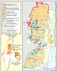
ISRAEL'S SEPARATION BARRIER, 2002
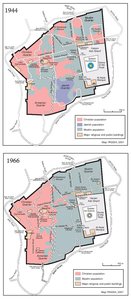
THE OLD CITY, 1944 & 1966
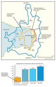
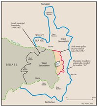
MUNICIPAL BOUNDARIES OF JERUSALEM, 1947-2000
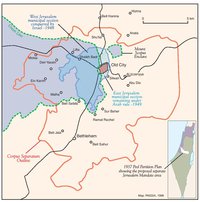
JERUSALEM AND THE CORPUS SEPARATUM PROPOSED IN 1947
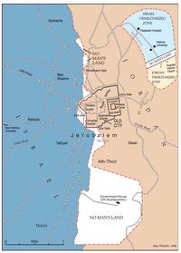
PARTITIONED JERUSALEM, 1948-1967
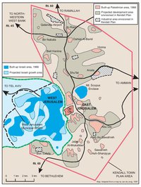
THE KENDALL TOWN SCHEME, 1966
JERUSALEM AFTER THE 1967 WAR
ISRAELI SETTLEMENTS AND PALESTINIAN NEIGHBORHOODS IN EAST JERUSALEM, 2000
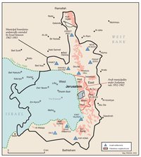
ISRAELI SETTLEMENTS AND PALESTINIAN NEIGHBORHOODS IN METROPOLITAN JERUSALEM, 2000
ARAB EAST JERUSALEM WITHIN ‘GREATER’ JERUSALEM, 2000
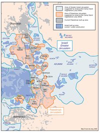
PROJECTION OF THE ISRAELI PROPOSAL FOR JERUSALEM’S FINAL STATUS AT CAMP DAVID, JULY 2000
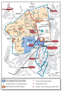
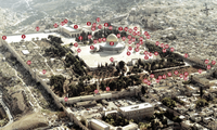
SETTLEMENT ACTIVITY IN THE OLD CITY
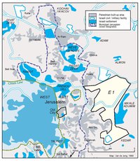
THE E-1 DEVELOPMENT PLAN
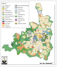
THE JERUSALEM MASTER PLAN
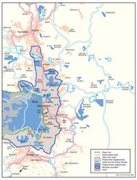
JERUSALEM TODAY (2014)