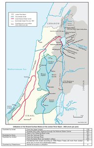
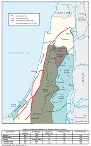
GROUNDWATER
Map Details
With no ability to utilize the surface waters of the Jordan River Basin, Palestinians are highly dependent on
groundwater. There are eight groundwater basins in Israel and the OPT, four of which lie within Israel
proper (Tiberias, Western Galilee, Carmel, and Negev basins), with the other four partially or fully in the
West Bank (North-Eastern, Eastern, and Western Aquifer) and Gaza Strip (Coastal Aquifer). The water
available from all the eight basins together is estimated at approximately 2,989 mcm per year, of which
1,454 mcm/yr emerges from groundwater, 1,320 mcm/yr is Jordan River surface water and 215 mcm/yr is
runoff. Of these resources, Israel exploits 89.5% while the Palestinians’ share is only 10.5% (271 mcm).
Groundwater is the only source for Palestinian water supply. Israel controls all aquifers in the country, of
which two major ones are shared with Palestine: the Northeastern and the Western Aquifer, even though
83% of the annual rainfall replenishment of these two and the Eastern Aquifer occur entirely within the
OPT. Palestinians utilize only 15% of water from the ground water aquifers while Israelis, including settlers,
utilize the remainder, 85%.
The Gaza segment of the larger Coastal Aquifer is the only water source in the Gaza Strip. Currently, Gaza
utilizes approximately 18% of this aquifer while Israel utilizes the remaining 82% of water. The safe annual
yield for the Gaza segment of the coastal aquifer was reduced to 55 mcm after Israel blocked the flow of the
Wadi Gaza replenishment source, which ran west from Hebron. Additionally, Israeli over-pumping in the
sections of the coastal aquifer beyond Gaza and the 10 mcm a year consumed by the over 6,000 settlers of
the Gaza Strip before the Israeli disengagement from Gaza in 2005, created a severe reduction in water
quality. As of 2014, only 5% of the Aquifer is considered fit for human consumption by WHO standards. The
Gaza aquifer is already over-extracted, leading the UN to estimate that Gaza will have no drinking water
within 15 years. It is widely believed that the Gaza Aquifer has already passed the point of no return and
needs to be regenerated before it can be sustainably used again.
Israeli settlement policy has been guided from the outset by the imperative of securing control over the
high-yield areas of the aquifers. As a result, the settlement master plans of past and present Israeli
governments conform in many respects to the outlines of the West Bank mountain aquifers. With the
signing of the 1995 Interim (Oslo II) Agreement, these settlement plans were translated into the cartography
of the A, B, and C zones of jurisdiction, seeing Israel’s intense urban settlement along the Western Aquifer,
its outpost settlements upon the Northeastern Aquifer and its agricultural settlement in the Jordan Valley
each rewarded with maintained dominance over West Bank groundwater and its recharge areas. Article 40
of Oslo II produced the only substantive agreement on groundwater usage of the Oslo process, but dealt
with the issue in terms of an immediate and temporary quota allocation and not in terms of equitable or
shared long-term control over the flow. The domestic consumption quotas this agreement created allotted
West Bank Palestinians one sixth the annual per-capita rate assigned the West Bank settlers and left Gaza
Palestinians with 30 times less water per-capita than the settlers living there. From all shared water
resources Palestinians currently utilize no more than 10%, while Israel exploits the rest.
Strategic schemes drawn up in Israel concerning the final status arrangements discussed in the Oslo
period, took as their starting point the premise that, “Israel must maintain exclusive control over its potential
pumping areas,” and that “the Palestinians cannot be allowed any further drillings…” In seeking to preserve
the inequitable and illegal status quo even in the context of a treaty with the Palestinians, Israel seeks to
legitimize its own continued reliance on seized Palestinian groundwater sources, while some 60,000
Palestinians currently living in Area C lack any access to running water and must pay high prices – up to
one-sixth of their income – to bring in water tankers, which in turn require special permits from the Israeli
authorities. Moreover, the Israeli separation barrier and settlements divest Palestinians of their water rights;
this is most apparent with regard to the Ariel and Kedumim ‘fingers’ near Qalqilya, which stretch 22 km into
the northern West Bank, covering only 2.2% of the occupied West Bank, but some of its most valuable
water resources. The Barrier isolates 28 groundwater wells in the West Bank as well as 17 springs and
has resulted in the de facto appropriation of agricultural wells in the West Bank. The damage inflicted on
the once prevailing Palestinian agricultural sector through the theft of groundwater has already been
evinced in a decline in the contribution of the agricultural sector to the Palestinian economy from 24% in
1966, to 4.8% in 2013. Control of the water means that while Israel’s large industrialized and irrigated
farms enjoy the economic benefits of crop diversity and guaranteed quota production, nearly the entire
Palestinian agricultural sector relies on rain-fed, low yield and low value seasonal production.
Israel's theft of Palestinian water sources – both ground and surface water – has left the Palestinians of the
OPT, where sufficient and replenishable high quality water is available, with the lowest per capita
consumption rate in the region by far, a dilapidated and incomplete network (with an estimated 30% loss
through leakage) and an increasingly saline, falling water level that offers little to no prospect for future
drilling even should Israel take the unlikely step of allowing this